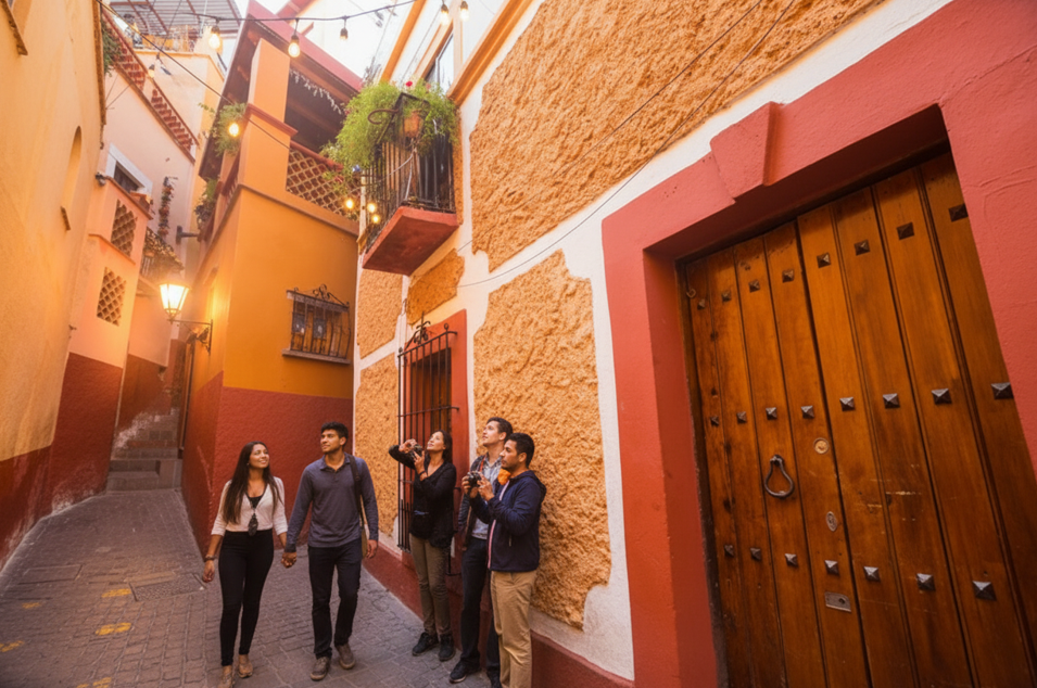
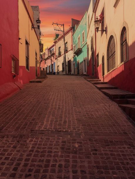
Callejón del Beso measures just 68 centimeters wide, with balconies so close you can reach across the gap. Tour guides tell you it’s about romance. The architectural reality? It’s about silver, steep hills, and what happens when an entire city grows without following any of Spain’s usual rules.
More about Callejon del Beso:
- Callejon del Beso Tours
- The Alley of the Kiss (Callejon del Beso): Everything You Need to Know About Guanajuato’s Most Romantic Landmark
The Grid That Never Was
In 1573, Spain published the Ordinances of Philip II. These rules said every new colonial town should have a central plaza with four main streets radiating outward in a grid pattern aligned to cardinal directions. Visit Mexico City or Lima and you’ll see this architectural plan executed exactly as written.
Guanajuato ignored all of it.
Why? Because by the time Spanish planners showed up with their grid papers, miners had already built four fortifications around silver outcrops discovered in the mid-16th century. Those forts—at Marfil, Tepetapa, Santa Anna, and Cerro del Cuarto—became the city’s starting points. Everything grew outward from the mines, not from a planned central square.
Night visit to the famous Callejón del Beso, the narrowest street in Mexico.
The difference between Guanajuato and other colonial cities is simple. Other cities were planned, then built. Guanajuato was built, then someone tried to plan it. By then it was too late.
Think of it like organizing your closet. Most people empty everything out, sort it, then put it back neatly. Guanajuato colonial architecture history is what happens when you just keep stuffing new clothes in for 200 years without ever taking anything out.
What Drove Guanajuato Architecture: Silver Economics Over Spanish Ideals
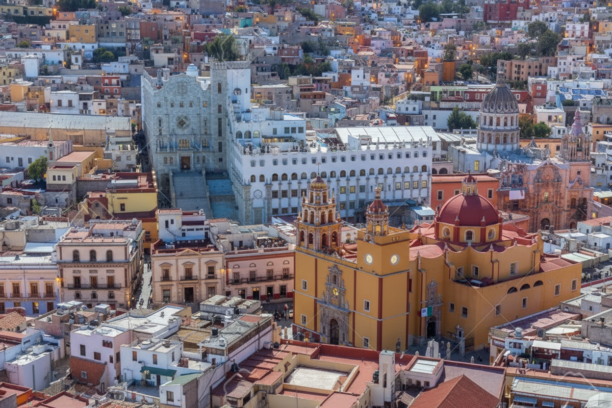
Guanajuato architecture emerged because miners needed proximity to wealth, not because planners wanted beauty. Between 1550 and 1800, this city produced more silver than any other location in the Americas. That single fact shaped every street, building, and narrow passage you see today.
Spanish colonial doctrine demanded specific architectural elements: 8-12 meter wide streets, uniform city blocks, buildings set back 1-2 meters from property lines. Guanajuato achieved none of these. Why? Because when La Valenciana mine produced two-thirds of global silver at peak output, every centimeter of buildable land near the ore became more valuable than compliance with distant regulations.
The architectural logic was brutal: mine owners, merchants, and workers all competed for space within walking distance of active mines. No one could wait for planners to survey ideal building sites. Construction happened wherever geology permitted—which meant steep slopes, irregular lots, and buildings pressed against bedrock and each other.
Why Guanajuato Houses Are So Close: When Mountains Override Planning Laws
The city sits in a narrow valley with streets that wind along the terrain, most too tight for cars, with some consisting entirely of steep stairs climbing the mountainsides. When you’re chasing silver veins through rock, you don’t wait to find flat ground. You build where the ore is.
By the 18th century, La Valenciana mine was producing two-thirds of the world’s silver at its peak output. That level of wealth created fierce competition for any buildable land. Every square meter of relatively flat ground had value.
People built upward on hillsides. They squeezed structures into gaps between rocks. They were constructed on slopes so steep that one building’s roof became another’s entrance. When you can’t expand horizontally, you go vertical and you build tight.
- The engineering reality of hillside construction forced architectural innovation. Standard colonial building techniques assumed flat ground and uniform foundations. Guanajuato builders had neither. Each structure required custom solutions: foundations carved into angled bedrock, load-bearing walls accounting for uneven settlement, upper floors cantilevered over narrow streets to maximize interior space.
- Cost comparison from colonial records: A 100-square-meter house on flat terrain in Querétaro cost approximately 800-1,000 pesos in construction (1750s pricing). The same square footage in Guanajuato cost 1,200-1,600 pesos due to slope excavation, irregular foundations, and material transport up steep paths. Builders compensated by reducing ground-floor footprints and building upward—cheaper to add a third story than to excavate more hillside.
Callejón del Beso sits on Cerro del Gallo hill, in an 18th-century neighborhood of winding cobblestone streets and baroque facades. The architectural design of balconies now separated by 68 centimeters wasn’t created for star-crossed lovers to kiss. They were designed to maximize rentable space on expensive land in a canyon where flat ground didn’t exist.
What Actually Happened to Urban Planning in Guanajuato
UNESCO notes that Guanajuato shows “a remarkable adaptation to topography in the organization of its narrow streets, gardens, piazzas and buildings” (UNESCO World Heritage Centre, 1988). That’s the diplomatic way of saying the city developed organically with zero regard for Spanish urban planning doctrine.
Here’s what that adaptation looked like in practice:
- Street Network: Paths followed mine routes and hill contours. Streets twisted around rock outcrops. Many became partially underground as the city built over its own infrastructure.
- Building Density: With expansion blocked by terrain, structures pressed together. Shared walls became standard. Alleyways narrowed to the minimum width two people could pass.
- Vertical Development: Buildings climbed hillsides in terraces. A structure might be two stories on the uphill side and five stories facing downhill.
The result was a city where houses at upper levels have balconies almost touching, with neighbors looking directly into each other’s windows. Not by choice. By necessity.
“Guanajuato proves that economic drivers override planning doctrine every time. The Crown wanted orderly grids. Miners wanted proximity to wealth. In that conflict, silver always won. Every narrow alley, every steep staircase, every building squeezed between rocks tells you Guanajuato’s real architect wasn’t a person—it was geology plus economics.”
Guanajuato transformed from temporary mining camp to permanent city in under 50 years—faster than any other colonial settlement in New Spain. This speed prevented organized planning and created the compressed urban landscape visible today.
- 1548-1600: Unplanned Origins Silver discoveries triggered immediate construction around four mine sites. These weren’t designed settlements—they were clusters of workers’ shelters, storage facilities, and defensive walls. No streets existed, only paths between ore processing areas and living quarters.
- 1600-1750: The Wealth Explosion As mines reached unprecedented productivity, the settlement gained permanent residents: mine owners building baroque mansions, merchants opening shops, the Catholic Church constructing ornate temples. Each group built wherever they could purchase or claim land. The result was architectural layering—grand neoclassical facades squeezed onto lots originally meant for single-room workers’ housing.
- 1750-1800: Maximum Density By the late 18th century, no vacant land remained in the canyon bottom or accessible hillsides. New construction meant building on top of, behind, or pressed against existing structures. This is when passages like Callejón del Beso reached their final 68cm width—not through planning, but through two property owners building simultaneously on adjacent steep lots and stopping only when their walls nearly touched.
- Alternative path that never happened: If silver deposits had been discovered 50 years later, after Spain’s 1573 urban planning ordinances were strictly enforced, colonial officials might have prevented uncontrolled growth. The city would have a grid, wider streets, and none of its current architectural significance. Silver arrived too early. Regulations arrived too late.
The Math of Building in a Canyon
Exploring the narrow alleyways leading to Callejón del Beso.
Let’s quantify what unusual planning actually costs.
- Standard Spanish Colonial Block: 100 meters by 100 meters, divided into four equal lots of 2,500 square meters each.
- Guanajuato Reality: Irregular lots ranging from 30 square meters (a house wedged between boulders on a slope) to 200 square meters (a mansion on one of the few flat areas).
- Construction Cost: Building on a 30-degree slope with irregular bedrock cost 40-60% more than building on flat ground according to colonial construction records. Load-bearing walls had to account for uneven foundations. Materials had to be hauled up narrow paths. Every structure required custom engineering.
- Space Trade-off: A family in flat Mexico City might have 150 square meters of living space on a 200 square meter lot. The same family in Guanajuato would have 80 square meters on a 100 square meter lot—but their balcony might be close enough to the neighbors that they could hand items across without stretching.
That last detail isn’t romantic. It’s a measurement of how desperately people needed housing in a boom town with nowhere to expand.
Why Are Guanajuato Houses So Close? Engineering Constraints, Not Design Choice
Guanajuato houses are so close because builders optimized for maximum rental income on minimal land. In the 18th century, a property owner with a 50-square-meter hillside lot faced a calculation: build one house 50 meters from the street with a long access path, or build two houses 25 meters apart sharing a wall. The second option doubled rental income using the same land.
Multiply that decision across 5,000 property owners building over 200 years, and you get a city where structures touch by default.
4 architectural techniques enabled extreme density:
- Shared structural walls: Adjacent buildings didn’t just share boundaries—they shared load-bearing walls. One structure’s west wall became the neighbor’s east wall. This cut construction costs 20-30% and allowed narrower footprints since each building gained stability from its neighbors.
- Vertical compensation for horizontal limits: When ground-level lots averaged 30-80 square meters (versus 150-250 in flat colonial cities), builders added stories. A three-story building on a 40-square-meter lot provided 120 square meters of usable space. The same family would need a 120-square-meter flat lot elsewhere—which didn’t exist in Guanajuato’s terrain.
- Foundation integration with natural rock: Instead of excavating and building separate foundations, builders carved directly into hillside bedrock. This created ultra-stable bases but locked each structure’s position permanently. You couldn’t adjust property lines later. Once built, the urban fabric became fixed.
- The proximity trade-off: Houses this close meant zero privacy, noise transfer, and fire risk. When one building burned, flames jumped to neighbors within minutes. Colonial records document multiple instances where single fires destroyed 10-15 attached structures. But when the alternative was no housing during a silver boom attracting 30,000+ workers, people accepted the risk.
Modern urban planners studying high-density development examine why Guanajuato houses are so close as a case study in building under extreme land constraints—constraints now facing cities worldwide as populations grow and available land shrinks.
How Colonial Economics Created Tight Streets
The spatial logic of 18th-century mining operations determined where every building could stand. Haciendas de beneficio minero—mineral processing factories—required river water for ore separation. This placed all industrial facilities in the narrow valley bottom, leaving hillsides as the only option for housing.
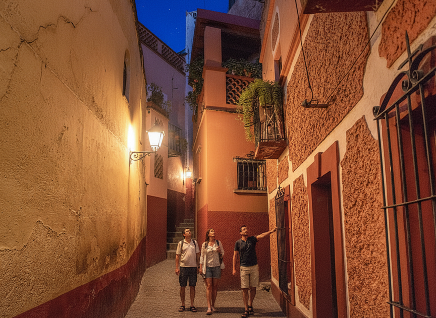
Evening atmosphere in the streets around Callejón del Beso.
Workers needed to live within walking distance of mines operating around the clock. Merchants needed storefronts near where miners spent their wages. Even wealthy mine owners had to build on whatever terrain was available. Social class determined building quality, not location flexibility.
Around 1750, two property owners on adjacent steep lots both built upward to maximize rental income. One built on what’s now Calle del Campanero, the other on Calle del Patrocinio. The gap between buildings wasn’t a romantic gesture or a planning mistake. It was calculated efficiency—wide enough for people to pass through, narrow enough that neither owner wasted valuable land.
The legend about forbidden lovers came later, probably invented by 20th-century tour guides when Guanajuato shifted from mining to tourism. It’s a good story. But the real story about economic pressure and geological constraints is better.
Comparison: How Different Was Guanajuato?
| Feature | Standard Spanish Colonial City | Guanajuato |
| Layout | Orthogonal grid, cardinal orientation | Organic, following topography |
| Central Plaza | 100-150m per side, single location | Multiple small plazas scattered |
| Block Size | Uniform 100m x 100m squares | Irregular 30-200m, highly variable |
| Street Width | 8-12m standard | 2-8m, many with stairs only |
| Building Setback | 1-2m from property line | Zero setback common |
| Stories | 1-2 stories typical | 2-5 stories on slopes |
Three Common Mistakes Visitors Make
Mistake 1: Thinking romance drove the design
The legend of Ana and Carlos—two young lovers from different social classes meeting secretly on opposing balconies—has become the alley’s defining story.
Missing the actual innovation. These 18th-century builders solved complex engineering problems on near-vertical terrain without modern equipment. They created a functional urban system in conditions that would stump contemporary developers.
You walk away thinking Guanajuato’s architecture is cute instead of recognizing it’s an adaptive design solution that influenced construction throughout central Mexico, as documented by UNESCO World Heritage records. The architectural innovations here became blueprints for other mining towns facing similar terrain challenges.
Mistake 2: Scheduling three hours to see one alley
Travel sites emphasize the landmark’s importance without clarifying its actual size.
The alley extends about 20 meters, mostly consisting of steep steps. Most visitors photograph the balconies and leave within 15 minutes. Those who scheduled longer end up killing time in overpriced tourist cafes, paying 180-250 pesos ($10-14 USD) for mediocre coffee.
2-3 wasted hours plus $15-25 on unnecessary food. Better plan: allocate 30-45 minutes maximum, then move to your next destination. The Pípila Monument, Museo de las Momias, or Mercado Hidalgo are all within 20 minutes.
Mistake 3: Judging 18th-century solutions by 21st-century codes
The passages seem dangerous by contemporary fire safety standards.
These streets worked for the materials, transportation, and building methods of their time. Failing to recognize that modern architecture still faces the same challenge—how to build densely in constrained spaces—means missing that Guanajuato solved 250 years ago.
Visitors spend time questioning why buildings are “too close” instead of asking what we can learn from adaptive design that predates modern urban planning by centuries.
The pattern across these mistakes: Tourists prioritize Instagram validation over architectural understanding. You photograph what looks unusual. You miss why it exists. Guanajuato’s buildings aren’t close for aesthetics—they’re close because geology, economics, and engineering left no alternative. That’s the story worth understanding.
When Guanajuato Almost Changed
In 1798, city officials proposed redesigning the historic center on a grid system. Influential mine owners blocked the plan. They’d already invested fortunes in properties following existing streets. Redevelopment would have bankrupted them.
If the grid plan had succeeded, Callejón del Beso wouldn’t exist. Neither would most of what makes Guanajuato architecturally significant. The town’s Baroque and neoclassical buildings, resulting from mining prosperity, influenced construction throughout central Mexico specifically because they show how to build grandly in difficult terrain.
An alternative path: If silver deposits had been found in flat terrain, Guanajuato would look like Querétaro or Zacatecas—orderly, predictable, and architecturally unremarkable.
The View from the Other Side: When This City Disappoints
Guanajuato’s layout may frustrate you if:
- You have mobility limitations. The historic center has several steps leading up to viewpoints, and due to the narrow alley width, it may be difficult for individuals with mobility issues to navigate. Most buildings lack elevators because there’s physically no room to install them in structures built into hillsides.
- You want to study standard colonial planning. This city is the exception, not the example. To understand representative Spanish colonial urbanism, visit Oaxaca or Guadalajara instead.
- You need modern infrastructure. Narrow streets mean limited vehicle access. Emergency services, deliveries, and parking create ongoing challenges according to Guanajuato’s city planning documentation. Many converted historic homes can’t accommodate modern systems.
- You’re sensitive to crowds in tight spaces. During peak tourist seasons and the October Cervantino Festival, the narrowest street in Guanajuato becomes packed with visitors. There’s no personal space in a passage 68 centimeters wide when 50 people want photographs simultaneously.
Honest assessment: If accessibility matters more than architectural history, or if you need open spaces for comfort, Guanajuato’s compressed historic center will frustrate rather than fascinate.
Why This Still Matters
The Historic Town of Guanajuato and Adjacent Mines became a UNESCO World Heritage Site in 1988. The designation recognized something important: adapting to constraints produces better architecture than forcing ideal plans onto resistant reality.
Modern urban planners study Guanajuato when designing high-density developments on challenging sites according to UNESCO’s Historic Urban Landscape documentation. The principles still work:
- Build to property lines when land is expensive
- Let topography guide street patterns rather than fighting it
- Accept that maximum efficiency rarely looks symmetrical
- Recognize that vertical development solves horizontal space limitations
“Developers today face the same problem Guanajuato solved in 1750—how to house growing populations on limited, difficult terrain. The difference is we have CAD software and they have pickaxes. Yet their solutions remain more elegant than many contemporary attempts. Sometimes constraints force better creativity than unlimited resources ever could.”
What Makes Guanajuato Architecture Different from Other Colonial Mexican Cities
Guanajuato architecture stands alone among colonial Mexican cities because it prioritized geological reality over European planning ideals. Compare it to peer cities and the distinctions become obvious.
- Oaxaca: Built in a wide valley with flat terrain. Spanish planners implemented their ideal grid with 100-meter blocks, uniform street widths, and central plaza exactly as written in the 1573 ordinances. Result: textbook colonial urbanism, architecturally unremarkable.
- Querétaro: Moderate hills allowed some terrain adaptation but maintained orthogonal street patterns and standard block sizes. Builders could expand horizontally when population grew.
- Guanajuato: Steep canyon with 30-45 degree slopes. Zero flat land. Impossible to implement any standard Spanish urban plan. Result: organic growth following terrain, creating architectural solutions found nowhere else in colonial America.
Contemporary architects studying hillside construction reference Guanajuato’s solutions for modern high-density developments facing similar terrain challenges (Historic Urban Landscape approach, UNESCO, 2011).
4 unique elements absent from other colonial cities:
- Subterranean street layers: As construction climbed hillsides, new buildings covered old streets, turning original ground-level passages into underground tunnels. The Túnel de la Calle Subterránea runs beneath the historic center—not planned infrastructure, but accidental archaeological layering as the city built over itself across centuries.
- Multi-elevation building entrances: A single structure might have its main door at third-floor level on the uphill street, while basement windows open onto a different street two stories below. This creates buildings that are simultaneously 2, 3, and 5 stories depending on approach direction—architecturally impossible in flat-terrain cities.
- Integrated retaining-wall construction: Buildings don’t sit on hillsides; they become part of the hillside’s structural system. Rear walls double as retaining structures preventing landslides. Remove one building, and you risk destabilizing the entire slope. This makes preservation mandatory for engineering reasons, not just historical sentiment.
- UNESCO’s recognition criteria (1988): Evaluators specifically cited “outstanding adaptation of architecture to topographic constraints” when designating Guanajuato a World Heritage Site. Translation: this city solved problems other colonial settlements never encountered because they had the luxury of flat ground.
Contemporary architects studying hillside construction reference Guanajuato’s solutions for modern high-density developments facing similar terrain challenges.
What to Do Around Callejón del Beso: Visitor Guide
From Plazuela de los Ángeles on Avenida Juárez, walk about 40 meters up Callejón del Patrocinio to see the tiny alley on your left. The address is Callejón del Beso S/N, Zona Centro, 36000 Guanajuato, Gto., Mexico.
Best timing: Tuesday or Wednesday mornings before 9 AM offer empty frames for photos. Weekend crowds turn the alley into a queue, and Valentine’s week is impossible.
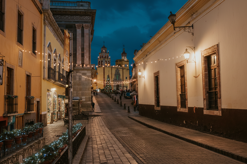
Colorful colonial houses lining a steep street in Guanajuato.
The alley itself takes 15 minutes. Understanding the architectural context that explains why is Callejón del Beso so narrow takes three hours. Walk the surrounding hillsides. Notice how houses stack vertically. Count how many buildings share walls. Look at foundations clinging to rock faces. That’s where the real story lives.
Architectural walking tour (2 hours, focuses on understanding, not just photography):
Start: Callejón del Beso – Note the 68cm gap between balconies. Observe how both buildings use the same hillside bedrock as their foundation—carved into the slope, not built on top of it.
Walk uphill via Callejón del Patrocinio – Count shared walls. Notice that most buildings share three of their four walls with neighbors. This wasn’t cooperation—it was economic necessity when land cost more than construction.
Stop: Plazuela de San Fernando – Small plaza demonstrating how public spaces emerged in leftover gaps rather than planned locations. The surrounding buildings show different construction periods (1650s baroque, 1750s neoclassical) squeezed onto the same irregular lots.
Continue to upper section of Cerro del Gallo – Buildings here demonstrate cantilevered construction: ground floors 40 square meters, upper floors extending to 60 square meters by projecting over the street. Legal because streets were public air rights, and property owners owned everything above their lot lines.
End at elevated viewpoint (Pípila Monument or hotel rooftop) – From distance, the architectural density becomes measurable. Buildings don’t sit in rows—they cluster in organic patterns following canyon contours. You can see how the city “flows” like liquid around geological obstacles.
Photography tip for architectural documentation: Ground-level photos show tight streets. Elevated photos reveal systematic responses to topography. Capture both perspectives to understand the complete design.
Entry is free. No tickets, no mandatory guides. But photographers offer kiss photos for 50-100 pesos ($3-6 USD), and souvenir vendors sell magnets and postcards for 30-150 pesos according to recent visitor reports.
Historic Center Guanajuato Attractions Near Alley of the Kiss
After visiting the narrowest street in Mexico, explore these nearby landmarks:
- Jardín de la Unión (5-minute walk): The city’s main square with outdoor cafes and neoclassical architecture
- Teatro Juárez (7-minute walk): Grand opera house showcasing ornate colonial design
- Basílica Colegiata de Nuestra Señora de Guanajuato (10-minute walk): Yellow baroque church dominating the skyline
- Museo Iconográfico del Quijote (8-minute walk): Art museum celebrating Cervantes in colonial mansion
- Alhóndiga de Granaditas (12-minute walk): Former granary turned history museum with revolutionary exhibits
Sights Near Alley of the Kiss Worth Your Time
The surrounding streets offer excellent examples of adaptive hillside construction. Walk Calle del Campanero and Calle del Patrocinio to see terraced housing, shared walls, and vertical integration of residential and commercial spaces.
For panoramic views showing how the entire city climbs the valley walls, hike to El Pípila Monument (20-minute walk uphill) or take the funicular (60 pesos round trip).
That 68-centimeter gap between balconies isn’t the minimum distance for a kiss. It’s the maximum efficiency of two property owners building independently on expensive land during a silver rush. The kiss came later. Economics came first. And that’s not a less interesting story—it’s an honest one about how cities actually develop when geology, wealth, and human ambition collide.